DOLOMITES 2017: A TOTALLY NEW COURSE, THE BEST OF THE DOLOMITES
Beginning the Haute Route Dolomites in Innsbruck, capital of the Tyrol region in Austria, is an inspired choice. Innsbruck is much closer to Venice than Geneva (the start or finish point for the last 3 editions) and above all it allows the race to take place entirely in one of the most beautiful cycling regions in the world, with no need for tiresome bus transfers and long rides up the interminable Swiss valleys.
With the exception of the last part of the last day, everything is new for the 2017 edition of the Haute Route Dolomites. Apart from Venice, we will not be using a single one of the towns we have visited in the past 3 years. The newcomers (Valle Isarco, Bressanone/Brixen and Canazei) are typical small Tyrolean towns, beautiful, charming and very welcome additions. We can expect great hospitality and a comfortable stay.
The bonus is that we get to stay two nights each in Bressanone and in Canazei, thus reducing the fatigue of changing hotel every night.
The search for a completely new course has led to some surprising omissions (the Sella, Gardena, Giau, Falzarego) but the choices are well made with many icons of the Giro included (Erbe, Valparola, Pordoi, Fedaia as well as the monster Timmelsjoch…)
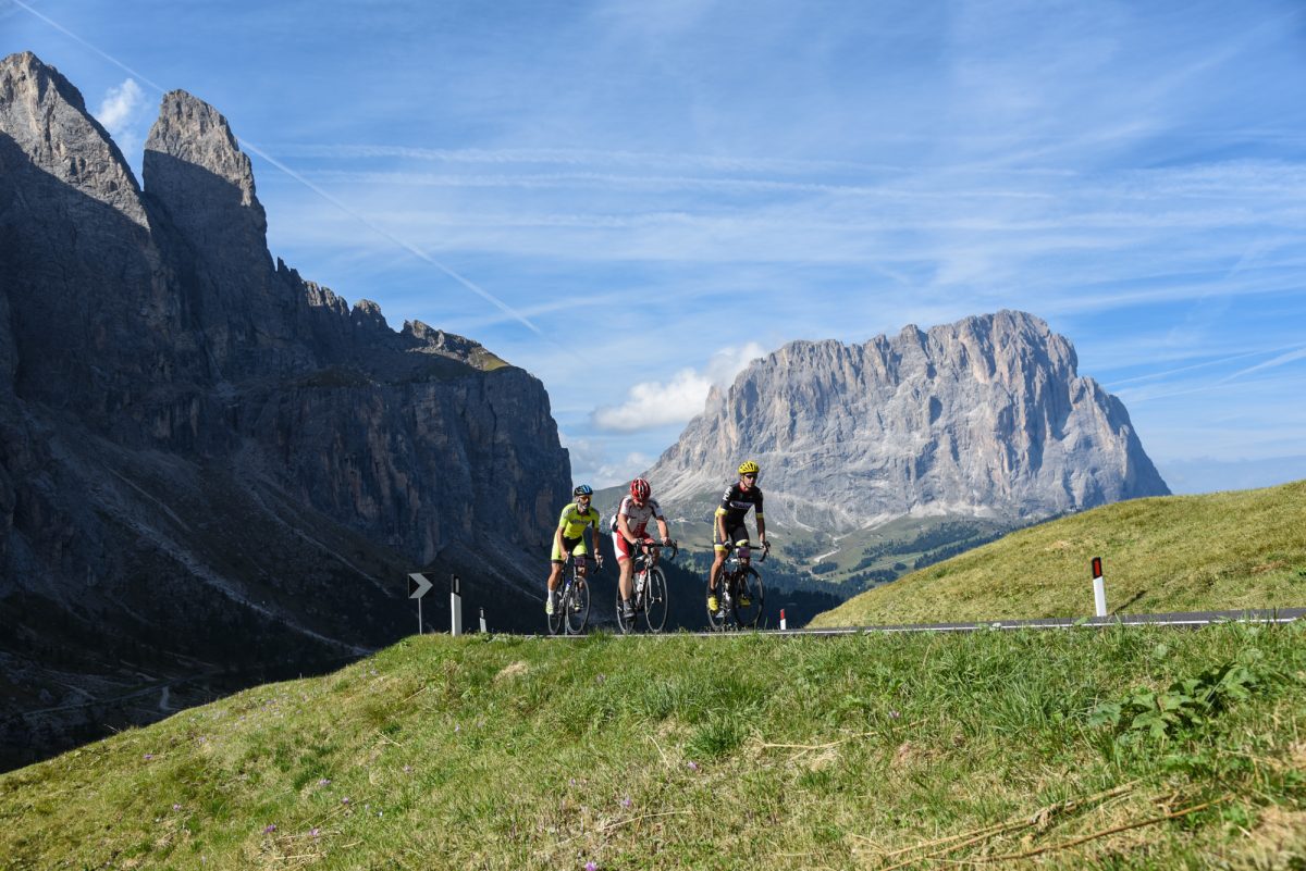
Some of these climbs are extremely challenging with long steep pitches. The two defining features of the Haute Route Dolomites 2017 from a rider’s perspective are the high proportion of steep climbs and long valleys.
You would be well-advised to practice long, steep climbs. Standing up on the pedals will be an essential skill. Bring a compact (50-34) or semi-compact (52-36) chainset and an 11-32 cassette.
Group riding skills will be particularly important. There are more than 250km of flat or false flat riding in the valleys where you could lose huge amounts of time if you ride alone. The Alpine Cols “pink high-speed train” will be in action: join the team for a first-class seat, or sneak on board at the back!
Overall the course looks outstanding, totalling 812km and 20,000m of hard climbing over the 7 days.
What’s not to like? Read on for the details!
STAGE ONE SATURDAY SEPTEMBER 2ND
INNSBRUCK – INNSBRUCK 113KM | 2900m+ ∗∗∗∗
There will be nothing easy about this first day. Don’t be fooled by the relatively limited amount of climbing: much of it is at gradients exceeding 10%…
It is likely to be a very fast beginning as we head west out of town on a flat road. It won’t last though: you’d better be ready to switch quickly to the small ring in Zirl around km 15: the first climb of the week is a wall 2km long at 16%. Normally this section of the road is forbidden to cyclists and if we do take it you will soon see why. Welcome to the mountains!
UPDATE ON 29/08/17: we received today the revised route details and are happy to confirm that we will not be taking this wall. We’ll climb to Seefeld via a more reasonable 8% slope, starting in Telfs.
The climb mercifully levels off to a more reasonable slope for the next 10km as we skirt the pretty village of Seefeld, the cross-country ski capital of Austria, before crossing the Mösern Pass (1,252m) and a very fast descent back down to the valley.
The serious work of the day begins after 80km, when we turn left and begin the long climb up to Kühtai (2,017m), the highest ski station in Austria, some 1,350m higher up. We are not taking the usual road, from Oetz, but a much smaller one from Haiming, taking us over a first pass at Obergut before a short descent through Ochsengarten to the main road and the second part of the climb to Kühtai.
The climb to Obergut is seriously tough, a relentless struggle at 11.5% for almost 8km. Talk about a beast! This is roughly the same profile as the Mortirolo…
A short descent and just 8km to go to Kühtai. The pain isn’t over, because there’s another 12-13% pitch, fortunately short.
It may be the highest, but Kühtai can’t be described as Austria’s most beautiful ski village: the road is wide, the architecture is late 20th century and the mountains are barren. Save your pictures for elsewhere.
Timing stops on the summit, and the day finishes with a very fast 40km descent back down to Innsbruck. Look out for cows on the road…
Once you are in, focus on recovery and get an early night because tomorrow is a big day…
STAGE TWO SUNDAY SEPTEMBER 3RD
INNSBRUCK – VIPITENO 176KM | 4200M+ ∗∗∗∗∗
Stage 1 gave a taste of some of the roads used by the Ötztaler Cycling Marathon, Austria’s answer to the Marmotte or the Maratona dles Dolomiti. Stage 2 will introduce us to another part of the 238km, 5,500m course, albeit in the reverse direction. Not for us the easy route into Italy, via the Brenner. We are heading for the Timmelsjoch!
This is the Queen stage and will be an epic ride, due to the 80km of cumulated climbing. It will be essential to conserve energy during the long approach to the Timmelsjoch by riding in a group at your level.
We start by the same route as yesterday, thankfully without the climb to Seefeld, and ride almost 50km along the valley floor before hitting the first gentle slopes that will rise eventually to the Timmelsjoch, the highest point of the week at 2,474m. It is not an excessively difficult climb from the northern side but will seem long, very long. By the time we get to the ski village of Sölden at km 86 we will have already climbed 600m over 40km. It gets steeper from here on, averaging around 5% all the way to Obergurgl apart from a couple of short sections at 11%. Keep something in reserve however for the final 5km, which averages 9% all the way… You will probably be feeling the altitude here. Expect your power to be down and don’t try to hold the same number you would on a lower climb.
The Timmelsjoch is one of the highest passes in the Alps, a watershed between north and south and attracts all the bad weather. The locals say it is unusual to get across in good conditions. Be prepared…
On the Italian side the Timmelsjoch is called the Passo del Rombo (which sounds ominous, and indeed the climb is much harder from the south…). Started by Mussolini, the road was only completed in 1968 and quickly became popular for its stupendous views. Trucks, caravans and coaches are banned, due to the narrow, steep descent on the Italian side. All the better for us.
The descent to San Leonardo is very fast and dangerous. The road is often in poor condition. Be sure to take it easy, eat and drink well and spin your legs during the descent, because likely to be a huge temperature difference between the summit and the bottom in San Leonardo, where it is often hot, and there’s another big climb to complete before the final descent into Vipiteno.
The Passo Monte Giovo (2,099m) is a spectacularly beautiful high mountain pass. From San Leonardo the climb is almost 20km at a fairly steady 7.1%. There are a couple of steeper stretches near the top, but nothing sustained at more than 9.5%. This is a relatively “normal” Alpine climb.
Once over the top it is an easy (but fast) freewheel down. If the weather is good it will be a delight… as will be the arrival in the Valle Isarco (perhaps at Vipiteno, a typically attractive Tyrolean town).
STAGE THREE MONDAY SEPTEMBER 4TH
VALLE ISARCO– BRESSANONE 107KM | 3000M+ ∗∗∗∗
There’s no warm-up on Stage 3, another tough one. We go straight into the 14.5km climb to the Passo Pennes (2,211m). The total climb is 1,263m at an average of 8.7%, and with the first two kilometres at 11.5% and 12.5%, there’s no chance to continue to doze on your bike. The climb is mostly in the forest before opening out near the top, where the road passes through an impressive cutting in the rock face. It’s a hard climb, one more to endure than enjoy.
Enjoy the next 35km descending through the picturesque Tyrolean scenery. Everywhere you look there are pretty villages, castles, churches and the ever-present mountains. Unfortunately, there is usually a headwind, so get in a group!
Your reverie (if such it is) will be broken when we arrive at the turn to the Renon plateau (1,383m), the first available short-cut up and over the mountains in the direction of Bressanone (Brixen in German). There’s an initially steep climb with wildly varying gradients up the side of the valley for 8km to where it levels out and descends again like a staircase for another 25km to the valley on the other side. We pass through lots of the attractive little villages for which the Tyrol is famous: it’s a real delight.
Following the main road along the valley floor to Bressanone would be much too easy, so we climb back up the valley wall for another 5km or so to enjoy the views one more time before the final descent to a well-earned rest at the arrival village.
STAGE FOUR TUESDAY SEPTEMBER 5TH
BRESSANONE – PLANCIOS 17KM | 1100M+ ∗∗∗
Bressanone is a jewel of a Tyrolean village and should delight those who don’t know it. It’s an inspired choice to spend a couple of days and to ride the Time Trial. The climb to Plancios (1,670m) is the major part of one of two alternative routes to the Passo delle Erbe (1,987m). It doesn’t have the mythical status of the Stelvio or Alpe d’Huez, but it will nevertheless provide a good test, representing 1,134m to climb over almost 20km. It’s a nice road, not too tough in terms of the gradient.
The average gradient is “only” 5.7%, but the climb is rather irregular so it won’t be easy to maintain a rhythm. You will find yourself constantly changing gear and pushing hard to maintain your momentum. Although you could ride a good part of it in the big ring, it would be easy to dig too deep on this climb and regret it the next day. As ever on the Haute Route, unless you are challenging for a place on the podium you would be wise to see the time-trial as a rest day.
STAGE FIVE WEDNESDAY SEPTEMBER 6TH
BRESSANONE – CANAZEI 120KM | 3900M+ ∗∗∗∗∗
There are no easy days on the Haute Route, but some are harder than others. After Stage 2, this is certainly the toughest.
By now you’ll be used to it: roll over the start-line and start climbing! The difference today is that the first climb is only 5km long, and is followed by a false flat descent before the second short climb and another chance to level out and spin your legs.
We are taking the alternative route to the Passo delle Erbe (1,987m), via San Leonardo and Luson. The real climb starts 3 or 4 km after Luson. Expect 11.5km at 7.9%. The first few kilometres are the steepest.
The road is straight and interminable: expect to suffer.
Your reward is the magnificent Dolomite scenery with its characteristic steep limestone cliffs. Simply stunning.
The first part of the 15km descent to San Martino is fast and dangerous, with the road in bad condition. It is interrupted by the short sharp climb above Alfarei, which can be a real shock to the system. In San Martino we join the main road for 15km and climb a false flat up the valley before the turn-off to the Passo Valparola (2,198m). This is another place where you must get in a chain-gang!
From the turn-off in La Villa we have 13.9 km to climb the 802m to the pass, which makes an average of 5.8%. The climb is highly irregular however with two 2km stretches in the first part at less than 3%. The second half is the hardest but the slope never gets above 10%, and reduces nicely for the last kilometre. We go past the Passo Falzarego on the way down, turning right and enjoying a beautiful descent through Cernadoi to the valley floor.
This area is full of reminders of the bloody battles fought between Austria and Italy in the 2nd WW: everywhere you look there are ruined military installations and memorials. It is hard to imagine the fighting as we cycle through peacefully today.
Almost 10km of false flat brings us to Arraba and the start of the Passo Pordoi (2,239m), legend of the Giro. Perhaps surprisingly, it’s not one to be too scared of. The climb is pretty regular, between 6% and 8%, rising 637m over 9.4km. You’ll go round some 30 hairpins: it is the classic climb of the Dolomites.
Once in the bag, a short descent (and another 26+ hairpin bends) brings us to our new home in Canazei.
STAGE SIX THURSDAY SEPTEMBER 7TH
CANAZEI – CANAZEI 103KM | 3000M+ ∗∗∗∗
Canazei is a great place to stay, so we’ll spend an extra night there to enjoy the best of the Dolomites. There’s an easy start today too, with a nice false flat descent for the first 15km through the charming little villages of Vigo di Fassa and Soraga. The climb to the Passo San Pellegrino (1,918m) starts in Moena and is fairly straightforward, averaging 6.8% over 11.4km. Expect a few steeper stretches where you’ll have to stand up but nothing too bad.
If it’s a hot day, you’ll be dreaming of that cold fizzy water on the eponymous summit!
A fast, mostly straight descent for the next 20km brings us to Cencenighe Agordino and the left turn up the valley to Caprile. The climb to the Colle Santa Lucia (1,485m) adds a loop above Caprile, but is well worth it for the views. Colle Santa Lucia is an outstandingly attractive small village on the pass. Well worth slowing down just enough to enjoy!
The climb is easy enough: just under 500m and 10km, nothing worse than the last kilometre at 8.6%. Yes! A good thing too, because you are going to need all your energy for the last climb of the day…
Back down to Caprile, we start immediately on the pièce de résistance, the Passo Fedaia (2,057m). Our start point is at 998m so we have 1,059m to climb, over 14.1km. This makes a reasonable-looking average of 7.5%. Do not be taken in! The first 7.5km are very easy, almost a false flat. Most of the height gain is in the last 6.5km, which average 10.3%, leading to yet more comparisons with the dreaded Mortirolo… Probably the worst part is a never-ending 3km straight after the waterfalls. When it does finally end, at the first switchback, the road only gets steeper! The steepest pitch is at 18%. If you don’t have a 32-tooth cassette, you will wish you did…
Thankfully, once over the top you only have to cruise around the lake and barely turn the pedals again before reaching the finish line lower down in Canazei.
STAGE SEVEN FRIDAY SEPTEMBER 8TH
CANAZEI – VENICE 181KM | 2600M+ ∗∗∗
Final day, and while certainly not the hardest, it is a long one at 183km. We begin by retracing our steps of the previous day, back up and over the Passo Fedaia (2,057m). Once again we begin with a climb, straight out of bed, as it were. Tomorrow in Venice is going to feel strange, no need to get up at 6am, no mountains to climb!
If you paid attention to the final descent on the previous day you’ll know what to expect. The climb is much easier from this side, but once again the second half is the toughest, with some 5km at 9%. Once over this, you can start to feel good. Two small hills left and the long ride out to Venice.
Most of the ride is along the valley floor, on a descending false flat, so very fast. I can’t emphasise enough how important it is to do this in a group and share the work.
The false flat descent is punctuated by the short climbs to the Forcella Franche (990m) and the Passo San Boldo (706m). The Forcella Franche consists of 5.5km of actual climbing, at 7%, and the San Boldo is a formality from the north. Timing will probably stop on the summit of the San Boldo: the race is over, time to relax and enjoy your achievement.
The descent from the San Boldo is a remarkable testament to human ingenuity and to what can be done when the stakes are high enough. This incredible road, consisting of a stack of tight hairpin bends cut into the solid rock, was built in just three months in 1918 by the Austro-Hungarian army and conscripted local women and children.
Next stop Conegliano for lunch, then on to Venice and the party!
Special thanks to Bryan Taylor from Verve Cycling/Infocrank for some of the insider knowledge!
THE WEATHER IN THE DOLOMITES
The biggest imponderable in the mountains is the weather. The same is true in the Alps and the Pyrenees, so it shouldn’t be a factor in your choice. The average number of rainy days in September in the Dolomites is between 6 and 10 so the likelihood of at least one wet day is quite high, and the altitude means that it is essential to bring the right clothes.
While warm, dry conditions are the most likely, you should be prepared for the two extremes of heat and cold. Beware especially of the potential for rain and temperatures only just above zero on the summits, and remember you will have to descend in these conditions. Don’t skimp on the quality of your clothes!
View from the saddle: the Haute Route Pyrenees 2017
View from the saddle: the Haute Route Alpes 2017
Alpine Cols is the official partner to the Haute Route for coaching and training. We offer coaching, training camps and Race Services, all intended to help you perform at your best and enjoy the experience. Between them, our coaches have ridden a total of 17 Haute Routes, as well as innumerable other mountain sportives, and they will be delighted to share their experience with you.
Alpine Cols clients benefit from a 10% discount on their registration fees to the Haute Route.